
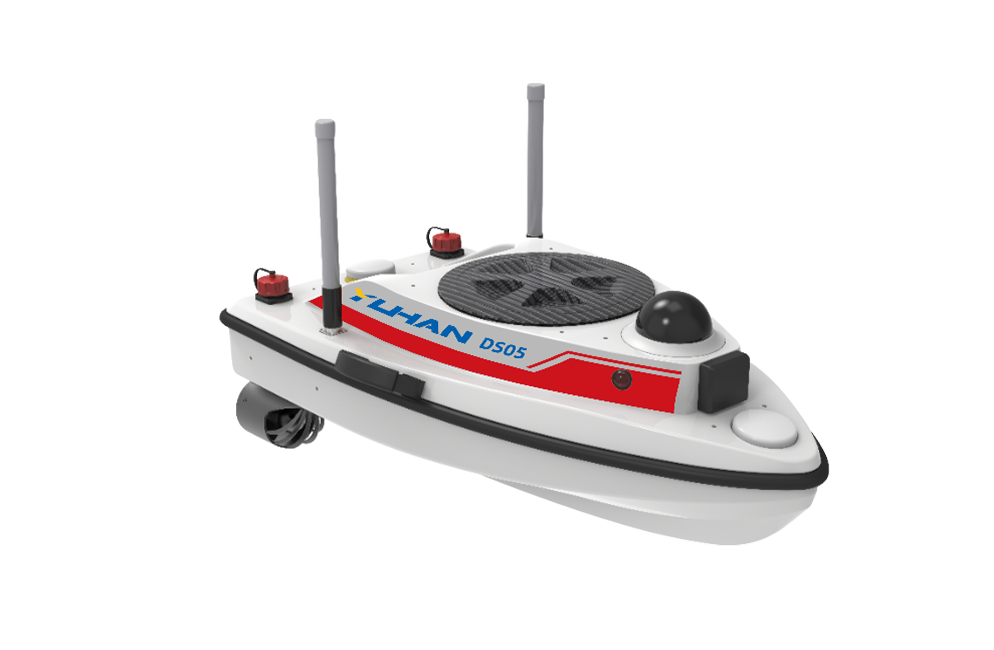

Survey Unmanned Vessel DS05
Ultra-Stability: Hydrodynamic hull + dual semi-embedded thrusters, ensuring stable navigation in turbulent rapids.
Five-in-One Integration: Centimeter-level positioning, underwater mapping, visual perception, communication redundancy, and active obstacle avoidance.
Powerful Propulsion: Adapts to diverse hydrological conditions from inland reservoirs to coastal waters.
Applications:
|
|
|
|


Core Features:
Five-Core Integrated Control Cabin: RTK centimeter-level positioning and orientation (dual GNSS aviation antennas + gyroscope and attitude sensor fusion), single-beam sonar depth measurement (capable of penetrating ultra-shallow water at 0.2m), 4G/radio station dual-mode communication (remote control with unlimited range), millimeter-wave radar obstacle avoidance, fully integrated boat control software. | Lightweight Operation System: Extreme portability: Fits in a car trunk; 3-minute lightning-fast deployment: Simply install the battery and antenna, and a single person can start the survey task; Battery life innovation: 6 hours of continuous operation + 90-minute rapid charging battery. |
Triple Anti-Entanglement Technology: Aerospace-grade alloy propeller: Corrosion-resistant and impact-resistant; Front and rear metal guard mesh: Physically blocks weeds/fishing nets; Hull-mounted sloped surface flow guidance: Reduces debris intake probability. | Full-Function Boat Control Software: Smart routing: Autonomous planning/resume from breakpoints/auto-return; Visualized mapping: Bathymetric color mapping + cross-section chart generation; Multi-source map support: Satellite imagery/custom map loading. |
Product Specifications:
Hull Dimensions: 80×40×23 cm Material: High-polymer composite material Hull Design: High-speed streamlined design Weight: 15 kg (including battery and equipment) Maximum Load: 20 kg | Wind and Wave Resistance: Force 3 wind, Level 2 waves Depth Range: 0.2 m – 120 m Depth Accuracy: ±1 cm ± 0.1%h Resolution: 1 cm Beam Width: 8° |
Product Images:
Mapping Unmanned Ship |
|